


Note- This essay was written in 2002. I’m re-running it as a companion piece for the commentary I posted last month on this Substack site: ‘Red Cedar River restoration & enhancement a cause for celebration.” Conservation and preservation (as much as possible) are among the causes worthy of embrace.
* * *
“Downriver there is a poetry to the Red Cedar. Tree-shaded banks, ivy-covered walls, the smell of lilac, the twilight shadows, and the remembrance of love long lost. But here, along the creeks and streams that feed the main river, we have the last traces of still untamed country.”
There’s a piece of ground several miles south of Howell that marks the boundary for three watersheds. Rain and melted snow running one way end up going south into the Huron River and eventually Lake Erie. The runoff flowing in a northeasterly direction finds its way to the Shiawassee River and Saginaw Bay, while water going westwards heads towards the Red Cedar River and then onward to the Grand River and Lake Michigan.
It’s this latter watershed, encompassing parts of western Livingston County and eastern Ingham County, that I’m most familiar with. The stomping grounds where I grew up and have grown older.
“Countless” would be my answer to how many times over these past 50 years that I’ve ridden over one of its bridges, walked alongside it as a fisherman, hiker or college student, or simply observed one of its many scenic stretches.
When you consider this geographical and cultural region called mid-Michigan (at least that part surrounding Lansing), this waterway and the Grand River are among the common denominators we share.
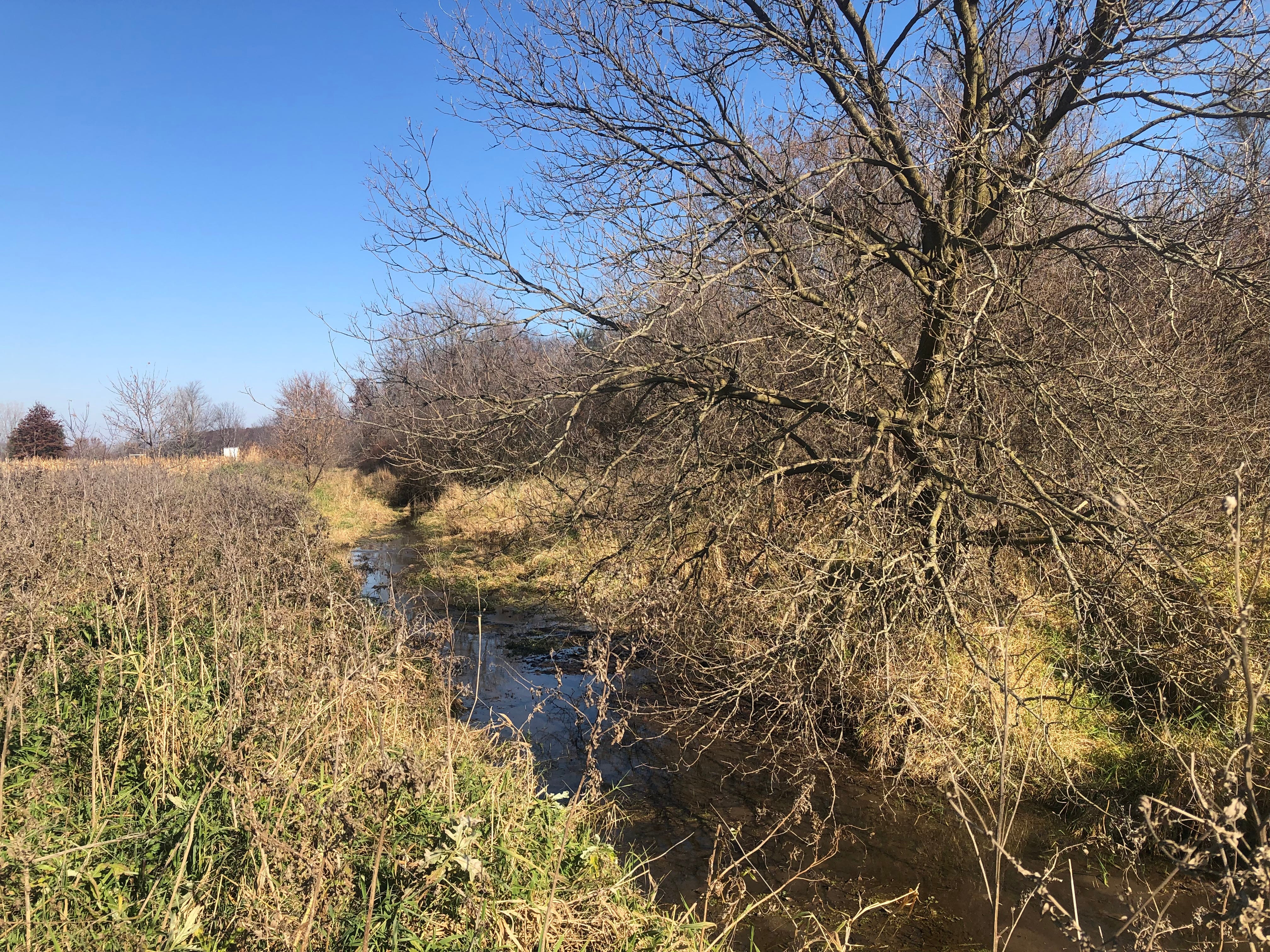
Upstream, there are actually three main sources to what becomes the larger Red Cedar. The river officially starts at Cedar Lake, north of Pinckney, and meanders in a leisurely manner, first north and then west, towards my hometown of Fowlerville. But there’s also a middle tributary, starting several miles south of Fowlerville, that heads due north and connects with the main branch just south of town.
Those combined flows go past the village, now taking a more northernly route. But shortly afterwards — behind Eggleston’s farm where I spent a few years of early childhood — it begins to bend more to the west.
About four miles later, near Webberville, another branch that’s also been flowing northward, connects. There are other tributaries, both natural and man-made, that likewise join the river along its route — Kalamink, Dean, and Deer Creeks, for example — but it is these three branches that have each been given the name of Red Cedar.
While the river eventually finds a more urban setting, most of its course is through farmlands, fields, and woodlots. Much of this bordering land was long ago tamed for the plow or cleared for grazing livestock, but there exists countryside too marshy or else left in a wilder (more natural) state and here the deer and partridge, fox and rabbit, woodchuck and raccoon, hawk and bluejay, and the other creatures who inhabit the forest, the overgrown meadow, the tangled swale, or the riverbank still have a place to roam and flourish.
My first memory of the Red Cedar was of following my father when we lived on the Eggleston farm (only back then it was called the Dean place) as he walked beside a ditch that drained into the river, spearing frogs. The reward was a plate of fried legs, served later that evening. Fried frog legs were one of my mother June’s favorite delicacies, an entrée that she often ordered whenever it was offered at a restaurant.
We later moved to a farm a little further to the northwest, but still near the river. The house and barns and most of the croplands sit on a plateau. To the south though, down a small slope, there is a neighboring muck farm where they once grew potatoes. Across the road from it is a marshy field where the owner used to pasture heifers during the warm weather.
My late grandfather said this lowland had once been a tamarack swamp and that the foundation beams in our farmhouse (as hard as rock) had come from the swamp.
The combination of cutting off the trees and then digging a drainage ditch, one of many in this area, helped dry the low-lying land enough to plant crops or seed pasture grasses. The river, being just to the south, took the run-off from this small watershed, known as the Bush Drain.
What’s beneficial in one place can prove to be less so elsewhere. All of the ditches dug many years ago (often by taking existing creeks and streams and enlarging them), all done for the purpose of draining this hinterland, while helping agriculture, has not always been good news downriver. The extra flow has made high-water situations here even worse. Of course, having a house in a flood plain, next to a river. does have its inherent risks.
But in hindsight, we understand these wetlands that the mid-Michigan pioneers found as a nuisance, as an obstacle to progress, did serve important purposes, one of them being flood control. Another key attribute is serving as a filtering and re-entry point for the replenishing of underground aquifers.
My grandfather, having grown up in this same farming neighborhood north of town, would also tell of swimming in the river when he was a boy. This would have been about 80 to 85 years ago.
But by the 1950s and 1960s, when I was a boy, that recreational option had ceased. In our pre-environmentally conscious days, Michigan’s rivers and lakes had become convenient places to dump sewage and industrial wastes. The Red Cedar was no exception.
This practice, combined with the growing use of chemical fertilizers and sprays — employed both for agriculture and lawn care — as well as there being much more cow manure around due to larger herds, had turned the river into a health hazard.
We still use the river to help get rid of our wastewater, only now the sewage has been treated, the wastewater tested, and what’s finally dumped into the Red Cedar is cleaner than what’s there. Also, care is taken so that these drainings do not adversely affect the aquatic plant life or existing fishery.
The commonplace dumping of industrial wastes has ended. It’s now illegal. Farmers have become more aware — or have been told to be more aware — of the health and ecological damages caused by run-offs of fertilizers, pesticides, and manure. And the indiscriminate dumping of gas and oil has been curtailed as well.
We’ve come a long way in the past 30 years since the passage of the Clean Water Act and the corresponding rise in environmental protection, although there’s still a ways to go, both in returning the river to better health (and thereby improving the status of wildlife dependent upon it) and keeping it that way. The eventual outcome will in large part be determined by what we do or don’t do, development-wise, on those lands — the watershed — that surrounds it. Current and future land-use — the mix of residential and commercial with farms and open spaces — is a key factor in the environmental equation.
This land-use is also a key factor in what cultural traditions survive and which ones fall by the wayside.
We’re still too often careless or unconcerned about the possible ill-effects of our decisions and our activities. Our connection to a river like the Red Cedar, and to the wild places and creatures near it, is not always given much importance when weighing the other needs and priorities of our modern times. And those who do express such concerns are often derided.
The river, as a common denominator, is a shared resource and heritage. So is the land alongside it. I trust there will remain “a poetry to the Red Cedar”… where young college students and returning alumni can stroll its tree-lines banks, smell the first flowers of spring, walk through the autumn colors on a football afternoon, watch the mixture of light and dark upon its evening waters, and sing of the MSU Shadows.
But I hope there will also continue to be fishermen, upstream, wading the shallows for pike or else standing on a country bridge, with pole in hand, during the annual run of suckers.
I pray there will remain a place where the fox can walk the river’s edge undisturbed, or where a boy can tag behind his father on a mid-Michigan farm, or where you might once again go swimming on an August afternoon.
To find a way to keep these uses and amenities while balancing the needs and necessities of manufacturing, growing towns, new homes, increased travel and traffic, assorted recreational pursuits, food production and all of the other aspects of civilized society — to somehow balance our urban and rural cultures and their respective traditions and to fashion a synthesis that embraces both — loom as one of our great challenges and perhaps among our most important endeavors.
What we do here in mid-Michigan holds much impact and future consequence. Will we keep those “last races of still untamed country”? Or lose them?
Steve Horton is a mid-Michigan journalist.